Memorial Day Weekend in Schroon Lake
Weekend event lineup for Memorial Day in Schroon Lake!
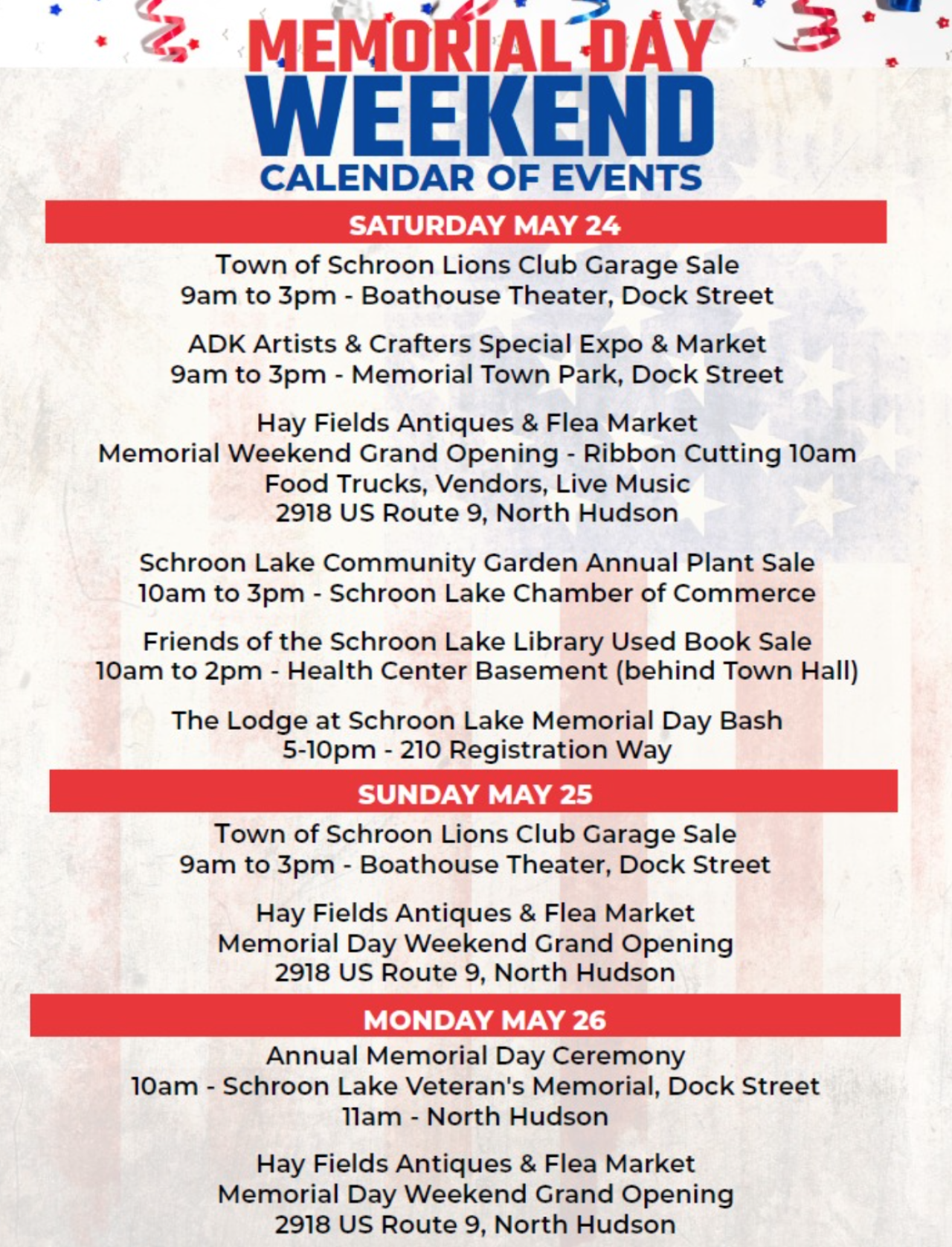
Weekend event lineup for Memorial Day in Schroon Lake!
Join us for an Ice Cream Social to kick off the summer season at the Historical Museum! FREE. Fun for the entire family! Call 518-532-7615 for more information.
On August 21, 2017, millions of Americans witnessed the first total solar eclipse to cross the continental United States in 99 years. As in all total solar eclipses, the moon blocked the sun and revealed its ethereal outer atmosphere - its corona - in a wondrous celestial spectacle. While hordes of citizens flocked to the eclipse's path of totality, scientists, too, staked out spots for a very different reason: to investigate the secrets of the sun's elusive atmosphere. During the eclipse's precious seconds of darkness, they gathered new clues on how our sun works, how it can produce deadly solar storms, and why its atmosphere is so hot. NOVA investigates the storied history of solar eclipse science, and joins both seasoned and citizen-scientists alike as they don their eclipse glasses, tune their telescopes, and behold the Eclipse Over America
A story of surprise and revelation. Martin Dohrn, a veteran wildlife filmmaker and a bee enthusiast, embarked on a special challenge during the COVID-19 lockdown of 2020: to film all the bees he could find in his tiny urban garden in Bristol, England. By the end of the summer, he became bee obsessed and developed relationships with some individuals.
NOVA explores ways that scientists are facing the climate challenge.
Weathering the Future: As extreme weather in the U.S. impacts more people–with longer heat waves, more intense rainstorms, megafires, and droughts–discover how Americans are fighting back by marshaling ancient wisdom and innovating new solutions.
Chasing Carbon Zero: The U.S. recently set an ambitious climate change goal: zero carbon emissions by 2050. And to achieve that, slash emissions in half by 2030. Is it possible? And what kind of technology would it take? Meet scientists and engineers who are convinced we can achieve carbon zero in time to avoid the biggest impacts of climate change.
Arctic Sinkholes: Scientists investigate colossal explosions in Siberia and other evidence that rapidly melting soil in the Arctic is releasing vast amounts of methane, a potent greenhouse gas. What are the implications for our climate future?
This self-guided snowshoe walk on the Rich Lake Trail is perfect for families and friends alike. Snowshoe among the luminary lanterns placed along the trail and enjoy the beauty of the forest at night. We’ll have a fire going at the Center with hot chocolate and warm cider to enjoy. Dress for the weather! Snowshoes are available at the AIC.
Dates:
Time: 6 p.m.
Join us for our Annual Easter Basket Giveaway! Saturday, March 30th from 12 pm - 2 pm at Minerva Beach. Sponsored by Its About Thyme Farm.
The Schroon Lake Arts Council presents an evening with "Annie & the Hedonists" - Big Band, Blues, and More! 7pm at the Schroon Lake Bandstand, Dock Street (rain location - Boathouse Theater).
Joe DeFelice will be performing at Paradox Brewery on Saturday September 7th from 5-8pm.
Seagle Festival’s traditional opening concert returns once again to start off the summer season. Join all thirty-one 2024 Seagle Festival emerging artists as they introduce themselves through song. A one-night-only event. Tickets are $45 for adults, and $35 for children 12 and under.
Stop by the Library on Tuesdays at 11 AM and you can learn the game of Mah Jongg.
Mah Jongg is an absorbing tile game of skill and chance. Beginning players are welcome to join and will learn the basic rules of play, how to use the current Mah Jongg card and how to select and strengthen a winning hand.
For more information contact the Library at (518)532-7737 ext 13.
Creative Healing Connections
VIRTUAL ARTS & HEALING SESSIONS
Offering a variety of sessions that focus on healing and connection.
Tuesday March 19th, 7pm-8pm
Remote Zero Balancing with Dan Sullivan, LMT of Adirondack Massage Therapy
Would you like to feel more at home with yourself, others and the world? Be centered, grounded and at peace - in body, mind and spirit? Discover and experience the Transformational Bodywork of Zero Balancing. Facilitated by Dan Sullivan, a NYS Licensed Massage Therapist living in Saranac Lake since 1999. Sullivan became certified in Zero Balancing in 2008 and a ZB Mentor in 2022 and received The Humanitarian of the Year in 2015 - The National American Massage Therapy Association. Participants should have a small piece of paper, a pen or pencil, and a quiet space to recline (couch, bed, sofa or a yoga mat on the floor).
Register now at https://www.creativehealingconnections.org/virtual-sessions
Stay on Indian Lake for three nights during the Boreal Birding Festival and get an additional 20% off our already off-peak prices.
Three-night stay at 30% off.
Celebrate love in the cozy charm of The Brown Swan this Valentine’s Day.
Unwind with us every Monday through Thursday from 4-6pm for the best Happy Hour in town!
Canadian Residents can use the code “BikeADKLovesCanada" will receive 15% off their registration!
Stay this winter at Rowe's Cabins and recieve 20% off your stay.
• One-night stay at 15% off.
Overnight accommodations at The Lodge at Schroon Lake & Exclusive access to 50% off Gore Mountain lift tickets for each registered guest
Experience the thrill of Adirondack waters with a half-day guided fishing trip or private chartered boat fishing trip for t
This spacious, lakefront home is th
This package includes overnight accommodations, round-trip shuttle service f
Don't ghost your getaway plans- spend Halloween lakeside with
Get the third night of celebrating mom for FREE!
Treat someone special to one drink of choice (iced or hot), a beautiful
This Mother's Day, give Mom the gift of tranquility and connection with a peaceful horseback trail ride through the scenic Adirondack forest at Circle B Ranch at 50% off!
Canadian Residents enjoy 25% off!
Two-night stay at 25% off
Celebrate Thanksgiving with a cozy escape to The Lodge at Schroon Lake, complete with a festive dinner at The Brown Swan!
Valentine's Day dinner for two at The Brown Swan, Champagne & Barkeater chocolates upon arrival and a two night stay at The Lodge at Schroon Lake.
Enjoy a complimentary third night when you book a three-night stay, a daily $25 dining credit, a
Enjoy game-day favorites from our special menu, featuring crave-worthy classics like wings, sliders, chili, and more, perfect for sharing or savori
Immerse yourself in the natural beauty of the Adirondacks with a professionally guided half-day hike or paddle for
Enjoy the tranquil lakeside getaway at a discounted rate exclusively for AAA members! Benefit from 10% off your stay as a valued AAA member.
Make memories that matter with a cozy stay in our spacious Family Glamping Tent—designed for comfort
Get ready to raise a glass and celebrate St.